Weather Forecast
Showers increasing today through tonight, then tapering off Friday, with some sun in the afternoon.
At a Glance

Today
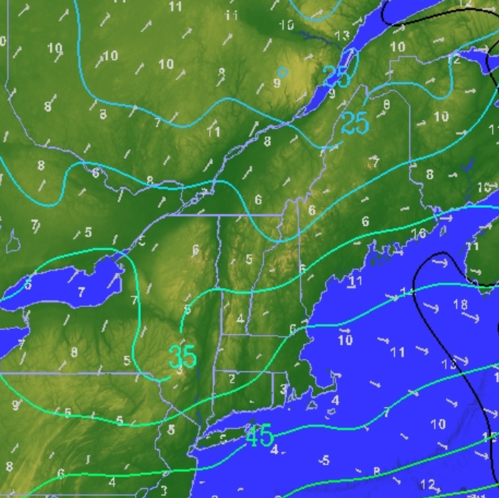
Showers, numerous with brief downpours from VT east, scattered west.
50s to near 60.

Thursday Night
Showers, scattered in NY and Quebec, numerous, brief downpours from VT east.
40s

Friday
Showers tapering off east, increasing sun from the west.
60 to 65, some upper 50s east

Saturday
Early valley fog, then partly sunny, warmer.
Upper 60s to mid 70s
Eye on the Sky Forecast, May 14, 2026
Weather Forecast
Extended Forecast | Significant/Hazardous Weather | Recreational Forecast | Detailed Discussion | Farm & Garden | Wind by Elevation | Temperature by Elevation
Detailed Forecast
Today:
Occasional rain and showers increasing from VT east, fewer in NY, increasing this afternoon, and scattered through the St. Lawrence Valley. Brief downpours and a rumble of thunder possible south. Highs in the 50s to low 60s. Southeast winds becoming east near 10 mph.
Tonight:
Occasional rain and showers, fewer in the St. Lawrence Valley, decreasing west of the Green Mountains overnight. Lows in the 40s. Winds light, mainly east less than 10 mph.
Friday:
Morning rain and showers through NH in eastern VT, tapering off west of the Green Mountains and through Quebec, where periods of sun develop, expanding east into the Berkshires and VT. Highs 60 to 65, except upper 50s east of the Green Mountains. Winds light, becoming northeast to north less than 10 mph.
Extended Forecast
Friday Night:
A few localized evening showers east ending. Gradual clearing overnight, and some patches of valley fog forming. Lows in the low to mid 40s. Winds light and variable.
Saturday:
Becoming mostly sunny and more seasonable. Some clouds west later in the day. Highs in the upper 60s to mid 70s. Winds light, becoming southwest near 10 mph.
Saturday Night:
Periods of clouds, mild, with a localized shower possible. Lows in the 40s to low 50s.
Sunday:
A mix of clouds and sun. An isolated shower or two. Highs in the upper 60s to upper 70s north to south.
Sunday Night:
Mostly clear and mild. Lows in the 40s to low 50s.
Monday:
Sun, mixing with clouds. Highs in the 70s, with warmer valleys near 80.
Significant/Hazardous Weather
None.
Recreational Forecast
Mountain Forecast:
The summits will be frequently in the clouds, together with periods of rain and showers. Temperatures won’t vary much, and winds continue moderate from the southeast. Friday starts with clouds obscuring the summits, lifting and breaking in the Adirondacks, as any showers give way to breaks of sun. The clouds will also lift through the Berkshires and Green Mountains, where morning showers decrease, and perhaps a little afternoon sun. Clouds will be lower, and showers more likely in the White Mountains. Lighter east to northeast winds, while temperatures remain about the same. The outlook for the weekend calls for partly sunny skies, with light to moderate southwest winds developing Saturday, turning to the northwest on Sunday. Much warmer temperatures on Saturday, just a few degrees cooler, but still seasonably warm Sunday.
Wind At Lower Elevations:
Winds today becoming east near 10 mph, with waves on the open waters of Lake Champlain near 1 foot. Tonight, winds light, mainly east less than 10 mph, with waves on the open waters of Lake Champlain near 1 foot. On Friday, winds light, becoming northeast to north less than 10 mph, with waves on the open waters of Lake Champlain near 1 foot. The outlook for Saturday calls for winds to be light, becoming southwest near 10 mph.
For more details on Lake Champlain, go to: https://forecast.weather.gov/product.php?site=BTV&product=REC&issuedby=BTV
Detailed Discussion
Damp, showery weather arrived yesterday, timed so that temperatures struggled to warm up much – upper 40s and low 50s were more like early April than mid-May. On the other hand, temperatures did not drop much last night, which gives us a much milder start to the day. In a nutshell, today’s weather features more showers, steadiest and heaviest in VT and NH, tapering off west tonight and east tomorrow. The details, though, are much more varied, thanks to the number of weather systems involved. Today’s showers will increase as weak low pressure extending from Quebec south to Long Island combines with a storm in the upper atmosphere, creating a southeast rotation to the moisture. It means a few scattered showers in the St. Lawrence Valley, while the rotation sends additional showers west through much of NY, mainly this afternoon and evening. The bulk of the rain and showers sweep north from MA through VT and NH, and into the Eastern Townships. Further, a storm well out in the Atlantic adds to the moisture feed for eastern areas, leading to some brief, locally heavy showers, especially through central and southern VT and NH, where a few rumbles of thunder are also possible. After the showers expand west into NY this evening, they diminish overnight, except through NH and eastern VT, lasting there into tomorrow morning as the upper atmospheric system drifts east, finally tapering to a few scattered showers by afternoon. At the same time, periods of sunshine develop in the St. Lawrence Valley and NY, expanding into most of Quebec and VT, perhaps into NH late. Temperatures should respond, easing into the lower 60s, while upper 50s remain with more clouds east of the Green Mountains. With skies clearing Friday night, some areas of valley fog may form, but they’ll burn off quickly, while we see a noticeable shift in the weather. Rather than a dominant northwest flow from Canada, a much warmer west and southwest airflow sends readings into the upper 60s and 70s Saturday, and we’ll enjoy a generous supply of sunshine thanks to high pressure sliding to our south. This does make room for a minor front Saturday night into early Sunday, just a stray, isolated shower possible, before more sunshine on Sunday, perhaps just a few degrees cooler for northern areas, ranging from the upper 60s to upper 70s north to south. It continues to warm up next week, with 70s to low 80s Monday, and well into the 80s Tuesday, a few warmer valleys south might attempt to reach 90.
Farm & Garden
Rainfall Forecast:
Rain and showers today, covering 90 percent of the region from the Green Mountains east, and 60 percent west, with amounts from 0.10 to 0.25 inches west, and 0.50 to 1.50 inches east. A chance of showers through NY into Quebec, mainly in the morning, covering 40 percent of the area, with amounts of 0.10 inches or less. Showers likely from VT east, covering 70 percent of the region, with an additional 0.10 to 0.25 inches. Mainly dry weather anticipated for Saturday and Sunday, though a localized, passing shower possible Saturday night into Sunday, with spotty, light amounts. Dry weather to start next week.
Drying Conditions:
Fair to poor drying today, with showers likely, and minimum relative humidities near 70 percent. Drying conditions on Friday should be fair through NY and Quebec, with any showers ending, and minimum relative humidities near 50 percent. Showers likely from VT east, diminishing through the day, with minimum relative humidities near 60 percent. Drying conditions improve to good Saturday and Sunday.
Frost:
Clouds and a chance of showers will keep readings well above freezing tonight through Friday night. Milder weather this weekend keeps us frost-free for the next several days.
Wind by Elevation
| Elevation | Today | Friday | Saturday |
| 2000ft | S 30>SE 20 mph | E 15 mph>light | SW 10>15 mph |
| 4000ft | S 40>SE 30 mph | E 20 mph>light | W>SW 10 to 25 mph |
| 6000ft | S>SE 35 to 45 mph | ESE 30>NE 10 mph | ESE 30>NE 10 mph |
Temperature by Elevation
| Temperature at Elevation | |||
|---|---|---|---|
| Elevation | Today | Friday | Saturday |
| 2000ft | 50s | 55 to 60 | 65 N/72 S |
| 4000ft | 40 to 45 | 40 to 45 | 55 to 60 |
| 6000ft | 30s | 30s | 40 to 45 |
Weather Journal
May 14, 2026
Sunrise: 5:25 AM
Sunset: 8:09 PM
Length of day: 14 hours and 44 minutes
A series of white frosts began on this date over two centuries ago, in 1816, a prelude to the infamous “Year Without A Summer”. The weather up until May had been progressing normally, even including temperatures in the 80s at the end of April. But the cold weather, cloudy skies, and occasional dustings of snow on the mountains greatly delayed the budding out of trees, and the flowering plants.
Current Conditions Maps – Quick Links

This program is a partnership between the Fairbanks Museum and Vermont Public.

