Weather Forecast
Flooding possible tonight; icy roads possible later tonight and early Thursday.
At a Glance

Wednesday Night
Rain, possibly heavy, changing to snow late.
Mid 20s to around 30 west, low to mid 30s east
Thursday
Scattered snow showers north, mainly northern mountains.
Upper 20s to mid 30s

Friday
Partly to mostly sunny.
Upper 20s to lower 30s south and CPV, mid to upper 20s elsewhere north

Saturday
Mostly sunny.
Low to mid 20s north, mid 20s to around 30 south
Eye on the Sky Forecast, December 11, 2024
Weather Forecast
Extended Forecast | Significant/Hazardous Weather | Recreational Forecast | Detailed Discussion | Farm & Garden | Wind by Elevation | Temperature by Elevation
Detailed Forecast
***FLOOD WATCH INTO THURSDAY MORNING FOR VERMONT, NEW HAMPSHIRE, THE ADIRONDACKS, AND BERKSHIRES***
Wednesday Night:
Rain, possibly heavy at times; rain changing to snow before midnight in the Adirondacks, and after midnight farther to the east; South winds 10 to 15 mph and gusting to 30 mph, becoming southwest.
Thursday:
Blustery and much colder. Snow showers likely in the Adirondacks, with 3 to 5 inches, and scattered in the central and northern Greens, with 1 to 3 inches; otherwise scattered snow showers, mainly in the afternoon. Velley temperatures nearly steady in the low to mid 30s; temperatures falling over high terrain. West to southwest winds 10 to 15 mph, gusting to 35 mph.
Thursday Night:
Snow showers likely in the Adirondacks, scattered from Lake George into the central and northern Greens. Partly cloudy elsewhere, except mainly clear in southern valleys. Lows in the teens to around 20, around 10 above in the cold spots northeast. West winds 10 to 15 mph, gusting to 25 mph.
Extended Forecast
Friday:
Chance of an early snow shower in the Adirondacks otherwise partly to mostly sunny. Highs in the upper 20s to lower 30s south and in the Champlain Valley, mid to upper 20s elsewhere north. West winds 5 to 15 mph.
Friday Night:
Mainly clear, with a few clouds through the mountains. Lows 10 to 15, with single numbers in the cold spots.
Saturday:
Mostly sunny. Highs in the low to mid 20s north, mid 20s to around 30 in the south.
Saturday Night:
Increasing clouds. Lows 5 to 15 above.
Sunday:
Chance of afternoon snow showers, mainly west of the Greens. Highs in the low to mid 30s in the south, mid 20s to around 30 north.
Significant/Hazardous Weather
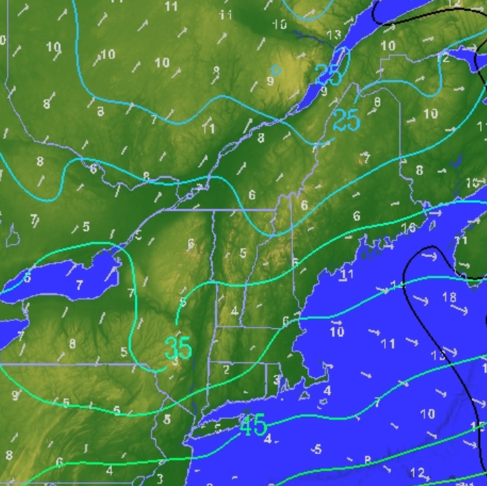
Rain and the risk of flooding will continue into the night, as low pressure passes nearly overhead, before intensifying late over Québec. A strong cold front will end the rain, with a changeover to snow that will be uneventful in most areas. But icy roads could develop overnight, as temperatures drop below freezing.
Recreational Forecast
Mountain Forecast:
Today summits are expected to be obscured in clouds and rainy weather. Rain will continue throughout the day today. Rain could be moderate to heavy at times, especially in the afternoon and evening. A blocking warm front will set up in an east-west orientation across southern New England. This in combination with a north-south oriented cold front perpendicular and set up along the east coast will pump significant moisture and warm air from the Gulf of Mexico up into the Northeast. Highs today will be unseasonably warm and mainly in the 40s. This will cause snow to begin to melt. Rain along with snowmelt has the potential to create isolated flash flooding in ravines, as well as urban areas. Additionally, the storm will bring strong winds, which could gust up to 60 mph, further complicating conditions. These winds, along with the heavy rain, will create hazardous conditions, especially in exposed areas. As temperatures drop overnight, rain may transition to snow as the air cools below freezing. Light snow accumulation is possible over the Adirondacks, but little to no accumulation is expected in other areas. The storm system is expected to cause disruptions in both the weather and travel, with ongoing risks of flooding and high winds into the evening.
Wind At Lower Elevations:
Today, south to southeast winds near 10 mph, gusting to 25 mph. The outlook for Thursday calls for west winds increasing to 10 to 25 mph, gusting 30 to 40 mph.
For more details on Lake Champlain, go to: https://forecast.weather.gov/product.php?site=BTV&product=REC&issuedby=BTV
Detailed Discussion
I’m sure many of you have noticed the steady rain this morning, and the warm weather. We have a storm system to thank for this warm weather. A warm front has set up in southern New England, with a cold front perpendicular along the eastern seaboard. This setup will continue to fuel the rain today as moisture and warm temperatures will continually be pulled up from the Gulf of Mexico. Today highs could reach into the upper 40s to low 50s. This warm weather might be an enjoyable break from the cold December air but it also means that snow is melting. The stored water in the snow will contribute to any runoff we see due to the excess rainfall. This storm is expected to produce 1.5 to 2.5 inches of rain but add that to snowmelt and runoff totals are much higher. This morning there is the potential for bouts of heavy rainfall. This could impact any morning commutes making it a bit slippery to travel. Many schools this morning have opted to delay or close due to the inclement weather.
Mid-morning to early afternoon we are expecting a brief break in the rain showers. Now this break won’t last forever. More rain showers return later this evening and will continue to have periods of moderate to heavy rainfall. This will occur as the low pressure system steering the storm finally begins to lift out to the north and east. Vermont will be in the best position to see the brunt of the storm with the most amount of moisture and lift heading right our way. Now what this means is that with excess water from snowmelt there is the potential for river flooding to occur today. Flash flooding however will be possible in isolated areas this morning due to localized downpours. The chance for flash flooding returns again this evening as the rain returns with another chance of heavy rainfall. Remember larger rivers take longer to respond to rainfall and therefore the crest is likely to occur later, after the majority of the rain has ended. The Northeast River Forecast Center has up to date forecasts and current river conditions, if you would like to track a river near you.
Farm & Garden
Rainfall Forecast:
The Farm and Garden forecasts will resume in April of 2025.
Drying Conditions:
The Farm and Garden forecasts will resume in April of 2025.
Frost:
The Farm and Garden forecasts will resume in April of 2025.
Wind by Elevation
| Wind Speeds | |||
|---|---|---|---|
| Elevation | Wednesday | Thursday | Friday |
| 2000ft | S 20 to 45 mph | WSW 20 to 35 mph | W 5 to 10 mph |
| 4000ft | SSW 35 to 50 mph | WSW 30 to 45 mph | WNW 20 to 30 mph |
| 6000ft | SSW 50>85 mph | WSW 50 to 65 mph | WNW 25 to 35 mph |
Temperature by Elevation
| Temperature at Elevation | |||
|---|---|---|---|
| Elevation | Wednesday | Thursday | Friday |
| 2000ft | 41 NE/50 SW | 30 NE/38 SW | 15 to 20 |
| 4000ft | 40s | 20s>15 | 5 to 10 |
| 6000ft | near 40 | teens>5 | -5 to 5 |
Weather Journal
December 11, 2024
Sunrise: 7:16 AM
Sunset: 4:11 PM
Length of the day:
8 hours and 55 minutes
Dusting off the record books on this date, December 11, 1966 was the climax of a very warm spell of weather. Burlington recording a high of 61 degrees for the third straight day, while it reached 63 in Keene, NH, and 65 in Dorset, VT. Even northern New Hampshire joined in with Berlin and 1st CT Lake at 63. Of course it didn’t last, as Waterbury, VT dropped 51 degrees, from 68 to 17, on the next day.
Current Conditions Maps – Quick Links

This program is a partnership between the Fairbanks Museum and Vermont Public.


